Multispectral
Advertisement
OptiSPeC v.1. 5. 2003
The OptiSPeC software package is designed for the analysis of multi-curve TCSPC data, such as multispectral FLIM data, anisotropy imaging or FLIM time series. Main concept of the software is the usage of measurement channels and analysis models.
MultiSpec v.2007.12.20
MultiSpec is a processing system for interactively analyzing Earth observational multispectral image data such as that produced by the Landsat series of Earth satellites and hyperspectral image data from current and future airborne and spaceborne sys
Advertisement
WinChips v.4 7
Chips, the Copenhagen Image Processing System, is a general-purpose software package for remote sensing image processing and spatial data analysis with extensive support for NOAA AVHRR data.
RGB Cube v.1. 1. 2001
This software displays the RGB cube transformation in different color spaces (RGB, XYZ, xyY, I1I2I3, UVW, LSLM, L*a*b*, L*u*v*, LHC, HSV, HSV Polar, CMY, HSI, HSI Polar, LHS, YUV, YIQ).
ColorSpace v.1. 1. 2001
ColorSpace and RGBCube are made freely available to promote knowledge of color. ColorSpace and RGBCube are 'research-grade' rather than commercial-quality softwares; they are used in color science teaching.
SatCon v.1. 5. 2003
SatCon is a software utility for converting raw binary data, as logged by SatView, into readable ASCII text suitable for import by third party applications such as spreadsheets or databases.
IIPImageServer v.0.9.9
IIPImage is an advanced high-performance feature-rich imaging server system for web-based streamed viewing and zooming of ultra high-resolution images.
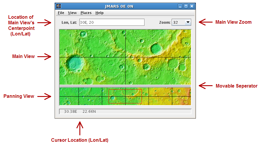
JMARS v.1.25
JMARS is an acronym that stands for Java Mission-planning and Analysis for Remote Sensing.